When you think about how the immense Ásbyrgi canyon was probably made, it surely ranks among Iceland’s most remarkable natural features. But if you don’t think about how it was made and just take it on face value, then it cannot be described as ‘breath-taking’ like many other Icelandic attractions – it is just an extremely pleasant place to be.
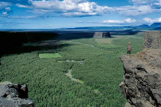
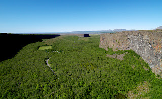
Ásbyrgi is one of the wonders of nature, a wide, horseshoe-shaped canyon with sheer cliff faces up to 100 m high. It is 3.5 km long and over 1 km wide. At its innermost end lies Botnstjörn, a small pond surrounded by luxuriant vegetation. A distinctive rock formation rises up from the centre of Ásbyrgi, up to 250 m wide, known as Eyjan.
The area is covered in woodland consisting mainly of birch, willow and mountain ash. Several thousand recently planted pines also prosper. Arctic fulmar nest on the steep cliffs, while many other birds prefer the woods and meadows.
Ásbyrgi was formed by two or more catastrophic floods caused by glacial bursts from the northern part of the Vatnajökull ice cap, one between eight and ten thousand years ago and a second approximately three thousand years ago. Since then the bed of the river has moved eastwards.
The original explanation for Ásbyrgi’s existence is that Sleipnir put a hoof down there and left a giant footprint (Sleipnir was the god Óðinn’s giant eight-legged horse). However, at about three-by-one kilometres in size, that would be a pretty big foot. So we’re going to assume that’s quite unlikely.
Although Ásbyrgi is part of the National Park, it is run by the Iceland Forest Service. The canyon has a shop and a restaurant.
Hiking trails at Ásbyrgi
Á-1 Botnstjörn pond
Distance: 1 km (circle) with other possibilities.
Walking time: ½ -1 hr
Starting point: At the innermost car park in Ásbyrgi canyon.
Path difficulty: Easy route (blue)
From the car park to the upper platform, under the west wall of the canyoun - Green route. Other routes in the area are mostly easy - Blue route.
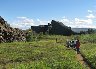
There are several easy and interesting routes in the bottom of Ásbyrgi, starting at the car park. A walk down stone steps leads to a platform at the small pond, Botnstjörn. There is also a nice view over the pond from a platform located underneath the west wall of the canyon. The route to this platform, from the parking lot, is suitable for people with restricted mobility. A few steps from the platform are stone steps that lead up to a small hill with a nice view over the Ásbyrgi canyon.
Á-2 Eyjan hill in Ásbyrgi
Distance: 4,5 km (back and forth)
Walking time: 1,5-2 hrs
Starting point: Car park in front of the service house at the campsite
Path difficulty: Easy route (blue)
The trail upon Eyjan (“the island”) in Ásbyrgi starts at the parking lot at the campsite. The trail heads first north and then it goes up the cliff where it is suitable for ascent. Wood steps have been put up for easier access. When up at the Eyjan the path goes soon past an old pile of stone. If you turn around there, the route is 2 km long, but if the path is followed further south, it goes all the way to the edge of the cliff. From there is a beautiful view over Ásbyrgi. This route is an enjoyable evening stroll.
Á-3 Through the woods
Distance: 4 km (one way)
Walking time: 1,5 hr
Starting point: Visitor Centre
Path difficulty: Easy route (blue).
Biking is allowed on this route. This route starts at the Visitor Centre in Ásbyrgi and goes follows a path that lies below the eastern wall of Ásbyrgi all the way south to the pond Botnstjörn in the bottom of the canyon. The route goes through various forestry plots as during the years 1947-1977 foreign conifers were planted in Ásbyrgi. Various bird species nest in the diverse forest groves. Prior to more modern lifestyles the birch wood was used for building houses, as firewood and for the grazing of livestock. It is possible to combine this route with route Á-4 and make a ring route.
Á-4 Below Eyjan hill
Distance: 3,5 km (one way)
Walking time: 1 hr
Starting point: Ásbyrgi Campsite
Path difficulty: Challenging route (red)
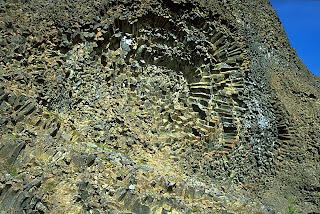
This route starts in the southwest corner of the campsite. First the route goes beneath the cliff wall where you can see the different forms of honey comb weathering. It is also possible to see the nest of the black raven (Corvus corax) which the gyrfalcon (Falco rusticolus) is fond of using for its own chicks. When at the south cliff of Eyjan the path goes west,you will notice big tussocks which are characteristical of the shrub heats of north east Iceland. The path ends at the old playing field in Ásbyrgi. It is possible to combine this route with route Á-3 and make a circular route.
Á-5 Áshöfði circle (around Áshöfði hill)
Distance: 7,5 km (circle)
Walking time: 2-3 hrs
Starting point: Visitor Centre
Path difficulty: Challenging route (red)
The route starts at the Visitor Centre. The path takes you first along the golf course to the east, towards lake Ástjörn where there is abundant birdlife. The path goes past the summer camp and east around the hill, were it starts to head south, past small ravines, a moorland and small ponds. Where the path turns west there is a beautiful view of the Jökuslá river. The path then goes north, along Gilsbakki. To go back to the Visitor Centre there are two routes to choose from: The easterly route goes along Ásgil and Ás. The westerly route goes to the rim of Ásbyrgi, Tófugjá and then you follow the route north, along the rim, towards the intersections at the east side of the golf course where there are a few hundred meters back to the Visitor Centre.
Á-6 Áshöfði circle (across Áshöfði hill)
Distance: 7 km (circle)
Walking time: 2-3 hrs
Starting point: Visitor Centre
Path difficulty: Challenging route (red)
This route is mostly equivalent to route Á-5. The route starts at the same site, at the Visitor Centre, and goes along the south end of lake Ástjörn, past the summer camp and east around the hill. But shortly before the view point over the Jökulsá River the route turns west at crossroads and follows a path over the Áshöfði hill. From the west side of the hill is a beautiful view over the old farm Ás, Ásbyrgi canyon and north over the sand which the Jökulsá River has formed, unimpeded for centuries but harnessed with levees today. When across the hill the route follows the same way back; across the summer camp and the south end of the lake Ástjörn.
Á-7 Klappir
Distance: 9 km (back and forth)
Walking time: 2,5-3 hrs
Starting point: Visitor Centre
Path difficulty: Challenging route (red)
This route starts at the same place as route Á-8. Please look at that route description. This route turns around at Klappir and goes the same way back. The route offers an excellent view over Ásbyrgi and you can see unique pot holes at Klappir, formed by catastrophic floods in the Jökulsá River.
Á-8 Kúahvammur circle
Distance: 12 km (circle)
Walking time: 4-5 hrs
Starting point: Visitor Centre
Path difficulty: Challenging route (red)
This route offers an excellent view over Ásbyrgi and the Jökulsá river canyon. The route starts at the Visitor Centre where there are two ways to choose from to get up the cliff. It is easier to go east along the golf course and turn south at the intersections. From there the route follows the rim of the canyon. The more difficult route is to go ~ 0,7 km south from the Visitor Centre, turn left at the intersection and climb up the cliff from there. There is a rope for support. From there the trail takes you along the eastern rim of Ásbyrgi as far south as Klappir where catastrophic floods in Jökulsá River have carved some amazing shapes into the rock. The view over Ásbyrgi is simply breathtaking. From Klappir your head east over the moor to Jökulsá and then along the gorge, passing Gilsbakki and Ás until you return to the starting point. It is also possible to go the same way back from Klappir (Á-7). Then the route is ~ 9 km long.
Á-9 Kvíar circle
Distance: 17 km (circle)
Walking time: 6-7 hrs
Starting point: Visitor Centre
Path difficulty: Challenging route (red)
This route gives an opportunity for a whole day walk throughthe diverse landscape of Ásbyrgi and its surroundings. The view on the route is spectacular and one can see unique remains of catastrophic floods in the Jökulsá River. The starting point of the route is the same as in Á-8. When at Klappir, instead of going east as in Á-8, the path is followed south to Kvíar. In Kvíar the various cataracts or enclosed hollows (named „byrgi“ in Icelandic) are clear remains of catastrophic floods. From the crossroads at Kvíar the route turns north and the easterly path along the Jökulsá River is followed. At crossroads in Kúahvammur the route is followed further north, along the same path is in Á-8.
SPECIAL 2 day trip HIKE
A hike from Ásbyrgi to Dettifoss
Hiking up along the Jökulsárgljúfur canyon, from the luxuriant Ásbyrgi to the barren but magnificent environment around Dettifoss, is a unique experience for every hiker. The diversity of the landscape is unique and captures the eye at every footprint: tremendous gorges, quiet ponds, clear springs, rough river, luxuriant forests and bare gravel plains.
Distances:
Here is a hiking map of Jökulsárgljúfur: [pdf 1.8 MB]
Route description
It takes two days to hike between Ásbyrgi and Dettifoss and normally lodged in Vesturdalur (Hljóðaklettar). The route can be walked in both directions (start ingeither in Ásbyrgi or Dettifoss). In Jökulsárgljúfur it is only allowed to camp at the official campsites in Ásbyrgi, Vesturdalur and at Dettifoss (a small campsite with few facilities).
From Ásbyrgi to Vesturdalur there are two paths to choose from: One is to follow the rim of Ásbyrgi, and go south along Klappir and Kvíar, just over 12 km. The other route is to go the easterly path, closer to the river, but that route is 13,6 km long. Both routes start at the Visitor Centre in Ásbyrgi.
From the Visitor Centre, there are two ways to access the rim of Ásbyrgi. An easier way is to go east over the golf course and turn south at the intersection east of the golf course. From there the path goes up the lowest part of the cliff. A more difficult way is to go directly south from the Visitor Centre, towards the intersection at Tófugjá. There, turn east and go up the cliff, where there is a rope for support. It is not recommended to go this way if people have a heavy burden. Up at Tófugjá it is possible to choose which way to go to Vesturdalur (along the rim of Ásbyrgi or along the Jökulsá river).
The route between Vesturdalur and Hólmatungur is about 8 km. The only river that has to be waded during the hike, Stallá, is at this section. Stallá is a spring river that flows into the Jökulsá river. The river is shallow and cold, but wading restores tired legs and makes the trip more memorable.
From Hólmatungur there is roughly a 10 km hike south to Dettifoss, if you go into the Hafragil lowland (black route). If you go along the Hafragil ravine the route is 11,5 km. It is not recommended for people with a heavy burden to go down to the lowland. In that case, hikers are advised to go to the campsite at Dettifoss, ease the burden and then explore the lowland.
Accommodation
On the route there are no cabins and it is only allowed to camp on the park campsites. In Vesturdalur there is a beautiful camp site. There are toilets and running, cold water, but no shower facilities. Please contact the rangers before camping. At Dettifoss there is a small camping area, only intended for hikers. The area is just north of the parking lot. There is no running water at the campsite, but rangers bring fresh water to the site every day. Please use the water spaerly.
Drinking water
Travel Information
The National Park's Visitors Centre, called "Gljufrastofa", is situated in Ásbyrgi. It is open during summer Tel.: 470 7100, e-mail: asbyrgi@vjp.is
We want to finish with Sigur Ros performing Hoppípolla at Ásbyrgi :)
Peter, Iceland24
January 2015
The area is covered in woodland consisting mainly of birch, willow and mountain ash. Several thousand recently planted pines also prosper. Arctic fulmar nest on the steep cliffs, while many other birds prefer the woods and meadows.
Ásbyrgi was formed by two or more catastrophic floods caused by glacial bursts from the northern part of the Vatnajökull ice cap, one between eight and ten thousand years ago and a second approximately three thousand years ago. Since then the bed of the river has moved eastwards.
The original explanation for Ásbyrgi’s existence is that Sleipnir put a hoof down there and left a giant footprint (Sleipnir was the god Óðinn’s giant eight-legged horse). However, at about three-by-one kilometres in size, that would be a pretty big foot. So we’re going to assume that’s quite unlikely.
Hiking trails at Ásbyrgi
Á-1 Botnstjörn pond
Distance: 1 km (circle) with other possibilities.
Walking time: ½ -1 hr
Starting point: At the innermost car park in Ásbyrgi canyon.
Path difficulty: Easy route (blue)
From the car park to the upper platform, under the west wall of the canyoun - Green route. Other routes in the area are mostly easy - Blue route.
There are several easy and interesting routes in the bottom of Ásbyrgi, starting at the car park. A walk down stone steps leads to a platform at the small pond, Botnstjörn. There is also a nice view over the pond from a platform located underneath the west wall of the canyon. The route to this platform, from the parking lot, is suitable for people with restricted mobility. A few steps from the platform are stone steps that lead up to a small hill with a nice view over the Ásbyrgi canyon.
Á-2 Eyjan hill in Ásbyrgi
Distance: 4,5 km (back and forth)
Walking time: 1,5-2 hrs
Starting point: Car park in front of the service house at the campsite
Path difficulty: Easy route (blue)
The trail upon Eyjan (“the island”) in Ásbyrgi starts at the parking lot at the campsite. The trail heads first north and then it goes up the cliff where it is suitable for ascent. Wood steps have been put up for easier access. When up at the Eyjan the path goes soon past an old pile of stone. If you turn around there, the route is 2 km long, but if the path is followed further south, it goes all the way to the edge of the cliff. From there is a beautiful view over Ásbyrgi. This route is an enjoyable evening stroll.
Á-3 Through the woods
Distance: 4 km (one way)
Walking time: 1,5 hr
Starting point: Visitor Centre
Path difficulty: Easy route (blue).
Biking is allowed on this route. This route starts at the Visitor Centre in Ásbyrgi and goes follows a path that lies below the eastern wall of Ásbyrgi all the way south to the pond Botnstjörn in the bottom of the canyon. The route goes through various forestry plots as during the years 1947-1977 foreign conifers were planted in Ásbyrgi. Various bird species nest in the diverse forest groves. Prior to more modern lifestyles the birch wood was used for building houses, as firewood and for the grazing of livestock. It is possible to combine this route with route Á-4 and make a ring route.
Á-4 Below Eyjan hill
Distance: 3,5 km (one way)
Walking time: 1 hr
Starting point: Ásbyrgi Campsite
Path difficulty: Challenging route (red)
This route starts in the southwest corner of the campsite. First the route goes beneath the cliff wall where you can see the different forms of honey comb weathering. It is also possible to see the nest of the black raven (Corvus corax) which the gyrfalcon (Falco rusticolus) is fond of using for its own chicks. When at the south cliff of Eyjan the path goes west,you will notice big tussocks which are characteristical of the shrub heats of north east Iceland. The path ends at the old playing field in Ásbyrgi. It is possible to combine this route with route Á-3 and make a circular route.
Á-5 Áshöfði circle (around Áshöfði hill)
Distance: 7,5 km (circle)
Walking time: 2-3 hrs
Starting point: Visitor Centre
Path difficulty: Challenging route (red)
The route starts at the Visitor Centre. The path takes you first along the golf course to the east, towards lake Ástjörn where there is abundant birdlife. The path goes past the summer camp and east around the hill, were it starts to head south, past small ravines, a moorland and small ponds. Where the path turns west there is a beautiful view of the Jökuslá river. The path then goes north, along Gilsbakki. To go back to the Visitor Centre there are two routes to choose from: The easterly route goes along Ásgil and Ás. The westerly route goes to the rim of Ásbyrgi, Tófugjá and then you follow the route north, along the rim, towards the intersections at the east side of the golf course where there are a few hundred meters back to the Visitor Centre.
Á-6 Áshöfði circle (across Áshöfði hill)
Distance: 7 km (circle)
Walking time: 2-3 hrs
Starting point: Visitor Centre
Path difficulty: Challenging route (red)
This route is mostly equivalent to route Á-5. The route starts at the same site, at the Visitor Centre, and goes along the south end of lake Ástjörn, past the summer camp and east around the hill. But shortly before the view point over the Jökulsá River the route turns west at crossroads and follows a path over the Áshöfði hill. From the west side of the hill is a beautiful view over the old farm Ás, Ásbyrgi canyon and north over the sand which the Jökulsá River has formed, unimpeded for centuries but harnessed with levees today. When across the hill the route follows the same way back; across the summer camp and the south end of the lake Ástjörn.
Á-7 Klappir
Distance: 9 km (back and forth)
Walking time: 2,5-3 hrs
Starting point: Visitor Centre
Path difficulty: Challenging route (red)
This route starts at the same place as route Á-8. Please look at that route description. This route turns around at Klappir and goes the same way back. The route offers an excellent view over Ásbyrgi and you can see unique pot holes at Klappir, formed by catastrophic floods in the Jökulsá River.
Á-8 Kúahvammur circle
Distance: 12 km (circle)
Walking time: 4-5 hrs
Starting point: Visitor Centre
Path difficulty: Challenging route (red)
This route offers an excellent view over Ásbyrgi and the Jökulsá river canyon. The route starts at the Visitor Centre where there are two ways to choose from to get up the cliff. It is easier to go east along the golf course and turn south at the intersections. From there the route follows the rim of the canyon. The more difficult route is to go ~ 0,7 km south from the Visitor Centre, turn left at the intersection and climb up the cliff from there. There is a rope for support. From there the trail takes you along the eastern rim of Ásbyrgi as far south as Klappir where catastrophic floods in Jökulsá River have carved some amazing shapes into the rock. The view over Ásbyrgi is simply breathtaking. From Klappir your head east over the moor to Jökulsá and then along the gorge, passing Gilsbakki and Ás until you return to the starting point. It is also possible to go the same way back from Klappir (Á-7). Then the route is ~ 9 km long.
Á-9 Kvíar circle
Distance: 17 km (circle)
Walking time: 6-7 hrs
Starting point: Visitor Centre
Path difficulty: Challenging route (red)
This route gives an opportunity for a whole day walk throughthe diverse landscape of Ásbyrgi and its surroundings. The view on the route is spectacular and one can see unique remains of catastrophic floods in the Jökulsá River. The starting point of the route is the same as in Á-8. When at Klappir, instead of going east as in Á-8, the path is followed south to Kvíar. In Kvíar the various cataracts or enclosed hollows (named „byrgi“ in Icelandic) are clear remains of catastrophic floods. From the crossroads at Kvíar the route turns north and the easterly path along the Jökulsá River is followed. At crossroads in Kúahvammur the route is followed further north, along the same path is in Á-8.
SPECIAL 2 day trip HIKE
A hike from Ásbyrgi to Dettifoss
Hiking up along the Jökulsárgljúfur canyon, from the luxuriant Ásbyrgi to the barren but magnificent environment around Dettifoss, is a unique experience for every hiker. The diversity of the landscape is unique and captures the eye at every footprint: tremendous gorges, quiet ponds, clear springs, rough river, luxuriant forests and bare gravel plains.
Distances:
- Ásbyrgi - Dettifoss, total: 32 km (shortest way)
- Ásbyrgi - Vesturdalur: 12 km or 13.6 km (see route description)
- Vesturdalur - Hólmatungur: 8 km
- Hólmatungur - Dettifoss (along Hafragil): 11.5 km
Here is a hiking map of Jökulsárgljúfur: [pdf 1.8 MB]
Route description
It takes two days to hike between Ásbyrgi and Dettifoss and normally lodged in Vesturdalur (Hljóðaklettar). The route can be walked in both directions (start ingeither in Ásbyrgi or Dettifoss). In Jökulsárgljúfur it is only allowed to camp at the official campsites in Ásbyrgi, Vesturdalur and at Dettifoss (a small campsite with few facilities).
From Ásbyrgi to Vesturdalur there are two paths to choose from: One is to follow the rim of Ásbyrgi, and go south along Klappir and Kvíar, just over 12 km. The other route is to go the easterly path, closer to the river, but that route is 13,6 km long. Both routes start at the Visitor Centre in Ásbyrgi.
From the Visitor Centre, there are two ways to access the rim of Ásbyrgi. An easier way is to go east over the golf course and turn south at the intersection east of the golf course. From there the path goes up the lowest part of the cliff. A more difficult way is to go directly south from the Visitor Centre, towards the intersection at Tófugjá. There, turn east and go up the cliff, where there is a rope for support. It is not recommended to go this way if people have a heavy burden. Up at Tófugjá it is possible to choose which way to go to Vesturdalur (along the rim of Ásbyrgi or along the Jökulsá river).
The route between Vesturdalur and Hólmatungur is about 8 km. The only river that has to be waded during the hike, Stallá, is at this section. Stallá is a spring river that flows into the Jökulsá river. The river is shallow and cold, but wading restores tired legs and makes the trip more memorable.
From Hólmatungur there is roughly a 10 km hike south to Dettifoss, if you go into the Hafragil lowland (black route). If you go along the Hafragil ravine the route is 11,5 km. It is not recommended for people with a heavy burden to go down to the lowland. In that case, hikers are advised to go to the campsite at Dettifoss, ease the burden and then explore the lowland.
Accommodation
On the route there are no cabins and it is only allowed to camp on the park campsites. In Vesturdalur there is a beautiful camp site. There are toilets and running, cold water, but no shower facilities. Please contact the rangers before camping. At Dettifoss there is a small camping area, only intended for hikers. The area is just north of the parking lot. There is no running water at the campsite, but rangers bring fresh water to the site every day. Please use the water spaerly.
Drinking water
- Between Ásbyrgi and Vesturdalur there are no streams or springs to take water from. Hikers have to carry all fluids with them.
- In Vestudalur there is running water in the toilet buildings. It is not recommended to drink water from the spring river due to high traffic of people in the area during the summer.
- In Hólmatungur there are a lot of streams from which is safe to drink water.
- Between Hólmatungur and Dettifoss the only spring river is down in Hafragil.
- At Dettifoss there is no running water. Park rangers carry water in tanks to the campground. Hikers are kindly requested to moderate the use of that water.
Obstacles on the route
The trail is mostly easy. The main obstacles on the route are:
- Tófugjá in Ásbyrgi is the way that goes up the rock wall of Ásbyrgi canyon. There is a ladder and rope for support. You can choose another way to get up to the rim. See route description.
- Stallá is the only river that has to be waded. It is shallow and cold but not a major obstacle for hikers.
- Hafragil lowland is the most difficult trail in Jökulsárgljúfur but also the most magnificent. People who carry heavy burdens, are advised not to go down to the lowland, as the path is really narrow in some areas. In Sanddalur the trail is really steep and there is a rope for support to go up/down. Furthermore, the trail goes along large boulders and there is a danger of falling rocks. For those who carry heavy burdens and want to explore the lowland it is better to go all the way to the campsite at Dettifoss, leave the luggage there and then walk back down to the lowland. Those who are afraid of heights are also not advised to go this route.
Travel opportunities
The trail from Ásbyrgi to Dettifoss is a one-way route. Hikers need to have plans to get back from the endpoint. There are two companies that offer regular transport between Ásbyrgi and Dettifoss, SBA and Fjallasýn. SBA offers daily tours between Dettifoss and Ásbyrgi from the 18th of June to the end of August. For more information, visit the SBA website. On reauest, the company Fjallasýn offers transport and/or guided tours between Ásbyrgi and Dettifoss. For more information visit the Fjallasýn website. The school-bus driver Guðmundur Þórarinsson also offers service to hikers and tourist,tel: 892-8928.
Travel Information
The National Park's Visitors Centre, called "Gljufrastofa", is situated in Ásbyrgi. It is open during summer Tel.: 470 7100, e-mail: asbyrgi@vjp.is
We want to finish with Sigur Ros performing Hoppípolla at Ásbyrgi :)
January 2015
