Showing posts with label iceland24. Show all posts

Green Driving Tips in Iceland

You CAN make a difference! 

As stated in our environmental platform, one of our objectives is to reduce emissions from the company´s car fleet. With regular maintaining and service, we keep our vehicles operating at peak efficiency. By following the „green“ driving tips below, you can improve your fuel economy and help us to reduce the negative environmental influence and create a greener future.

Plan routes and consolidate your trips: 

Whether going for a longer vacation or a quick trip, plan out your routes in advance to avoid heavy traffic periods and areas. If rush hour or road construction leads to traffic jams and stop-and-go driving, sometimes, the longer route can consume less fuel than a shorter one. So plan your routes to enable you to bypass congested routes and lead to fewer start-ups and less stop-and-go driving. Try to combine several short trips into one to save fuel and cut down on pollution. Warmed-up engines produce lower emissions.


Lighten your load and reduce drag: 

The more weight a car carries, the lower its fuel economy will be. Only pack what you need for vacations (including emergency items), and remove items that are not needed. Remove unneeded roof boxes, trailers and other items from your vehicle that cause wind resistance. These simple steps can cut significant weight and reduce drag, enabling your car to use less fuel.

Avoid quick starts, reduce your speed and keep the RPMs down: 

A smooth, steady speed improves your fuel economy, saves gasoline and reduces wear and tear on the engine, tires, transmission and brakes. As speed increases, so does drag. So, driving at higher speeds will reduce your fuel economy. Avoid quick starts. Putting the pedal to the metal when the stoplight turns green, increases your vehicle’s RPM level and lowers your fuel efficiency. Staying at or a bit below the speed limit and watching your RPMs can have a big impact on the environment and can lower your fuel cost. For every 15 km per hour you reduce speed, you can improve your fuel economy by 10 – 15%.


Think ahead in traffic: 

Try to anticipate stops and let your vehicle coast down as much as possible. Avoid the increased pollution, wasted gas and wear on your brakes created by accelerating hard and braking hard. Be smart as you navigate your way through traffic. Create space from the car in front of you and look ahead for any potential.

Keep a recommended air pressure in your tires: 

Maintaining recommended tire pressure can improve fuel economy as much as 6 percent. Over time, tires lose air pressure and as the air pressure decreases, rolling resistance increases and that makes your vehicle less fuel efficient. Recommended air pressure for your tires is shown in your vehicle’s owner’s manual.

Peter
Iceland24
May 2015

Krafla Caldera - Planning a Trip in Myvatn and Krafla

Krafla is a volcanic area in the northeast of Iceland, and one of Iceland’s largest lava lover lures. Craters, cones, pools and geothermal heat – Krafla has it all.

Krafla is basically a 10 kilometre wide caldera which contains volcanoes – the latter containing a small azure-coloured geothermal pool and the former containing Iceland’s deepest lake. Both are inland in the Highlands and only accessible in the height of summer.


But the Krafla area starts close to Lake Mývatn and only a few minutes’ drive from Reykjahlíð village. At this convenient nearest point, accessible in any car, you will find the remains of the lengthy mid-80s eruption. This means a large, relatively flat area to explore and the opportunity to get up close and personal to spiky lava, hot pools, bubbling mud, ‘eggy’ sulphur smells and the expansive power station in the area.

The large Krafla geothermal power station takes full advantage of the volcanism in the area and its run-off is used in the lovely Mývatn Nature Baths. The site is also home to the first drill hole of the fascinatingly exciting Iceland Deep Drilling Project.


The project looks to harness the power of “super critical” water in energy generation and this involves drilling down to the lava where large quantities of water can quickly be heated to over 400°C. The project aims to drill around 4 km below the surface – but at Krafla the scientists and engineers hit lava at just 2,500 metres. That’s shallow!

Krafla is a sensitive site and is easily damaged by people walking around and exploring. That is the reason the site is so well marked with footpaths and trails. These, combined with the good car park and bathroom facilities make Krafla a good place to go hiking with children and people with somewhat reduced mobility. The paths may be suitable for wheelchairs in good weather, although they can get soft and muddy in wet conditions.


Krafla is the best place to see first-hand where Iceland comes from. The whole country used to look like this at one point – as in fact did almost every country if you look far enough back into prehistory. It makes a good contrast with places like the Reykjanes peninsula down south, which features the same sort of landscape, except a few thousand years older. The difference is at once both stark and surprisingly little.


One thing is for sure: we all owe our lives to volcanoes and given long enough, Krafla will develop into remarkably fertile soil. But none of us will be alive to see that…

Krafla Geothermal Power Station

Development for harnessing of geothermal steam at Krafla, near Lake Mývatn in north Iceland, began with trial boreholes in 1974. Construction work commenced in the summer of 1975. The powerhouse and other structures were designed for two 30 MW turbines.

The station was initially designed and built for the Icelandic State and was run by the Krafla executive committee and later taken over by the State Electric Power Works. In 1985 Landsvirkjun purchased the Krafla station from the State.


Various initial difficulties were encountered in exploration and drilling for steam, largely due to seismic and volcanic activity which caused corrosive magma vapours to enter the geothermal system, destroying the borehole linings. A series of nine volcanic eruptions began in the vicinity of the station in December, 1975 and lasted intermittently until September 1984. Seismic and volcanic impact on operations at Krafla has been gradually diminished since then.

In 1996, Landsvirkjun decided to complete the install action of the second unit. Drilling for steam began immediately using improved drilling technology which has proved highly successful. Electricity production from the second unit began in November 1997, and since late 1998, the Krafla station has been operated with full capacity of 60 MW, as originally planned.

Get there by bus from Mývatn
.
18/6-10/9

Daily
18/6-10/9

Daily
 From
To
SBA-NordurleidTimetable
Tel: 553-5999
sba@sba.is
08:00
08:15
x
11:30
11:45x
arrow-from.GIF (274 bytes)


Berglind Rós
Iceland24
April 2015

Skagafjörður

Skagafjörður is a wide fjord, maybe even a bay, in Northwest Iceland (not the Westfjords) which is home to the large town of Sauðárkrókur and some lovely natural surroundings.

Skagafjörður

Another great thing about Skagafjörður is that it’s a little bit off the beaten track because, despite the presence of Sauðár- krókur, the Route 1 highway does not pass through. Or, more accurately, it only passes through very briefly and you could easily miss it.

Skagafjörður

Skagafjörður is a fertile farming region and particularly famous for its horses. Apparently it is even the only part of Iceland where horses outnumber people. For the record, sheep outnumber people in Iceland as a whole. Just so you know.

Skagafjörður

The people of Skagafjörður are known for being open and eccentric, in a nice kind of way. The tiny town of Varmahlíð – which Route 1 actually does pass through – is the base of North Iceland white water rafting on the East Glacial River. This is one of the top spots for rafting in all of Iceland.

Skagafjörður

Sauðárkrókur has over 2,500 people, which makes it the second biggest town in the north, after Akureyri. Icelanders generally find it hilarious to translate the name of the town directly as Sheep River Hook. Weird, right?

The town is pleasant, modern and open with a few good attractions including a museum and a surprisingly interesting rock exhibition. In the winter there is a well-liked ski area by Sauðárkrókur and plenty of hiking opportun- ities. There are also a couple of islands in the fjord and boats in the harbour you may be able to get there on.

Skagafjörður

Skagafjörður is home to Glaumbær farm, a beautiful old fashioned agricultural centre, now open air museum – and one of the cutest opportunities to take quaint oldy-worldy photos anywhere in the country.

Skagafjörður

The Icelandic Emigration Centre is in the Skagafjörður region and you will find it in the town of Hofsós, which is a pleasant village of 200 people which has recently been remodelling itself to better cater to tourists. This means, among other things, that the place is well-maintained.

Skagafjörður

Skagafjörður is roughly a hundred kilometres from Akureyri and 300 kilometres from Reykjavík. There is an airport in Sauðárkrókur which is not used for scheduled flights. Akureyri, on the other hand, has lots of scheduled flights and there are plenty of coaches (and even city buses) along Route 1.

Peter, Mars 2015
Iceland24

Surfing in Iceland? Icelandic surf guide

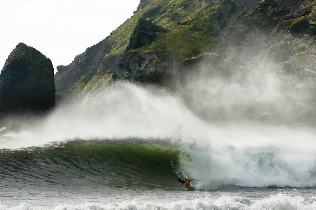
While surfers have been wandering the globe in search of perfect waves for a solid 50 years now, until recently, in order for a place to be considered a surfing mecca it had to meet the idyllic tropical threshold: swaying palms, warm water, powder-white beaches. It’s no wonder places like Tahiti, Fiji, and Indonesia have well-beaten paths. But true adventurers are always on the frontier, which, in surfing circles, is getting pushed farther and farther away from the equator.


This movement has been fueled largely by incredible advances in wetsuit technology. Softer, lighter, more flexible rubbers that have been developed in Japan have been incorporated by every major wetsuit manufacturer, and subsequent advances in fit and ergonomics have dramatically improved comfort for surfers in cold locales. Today, a place like Iceland, which was once considered impossible to surf, is suddenly on the surf-adventurers map.


California’s Chris Burkard is one surfer who never let the cold stop him. “I grew up on the Central Coast of California, which has chilly water year-round, so that part never intimidated me,” he said. As a staff photographer for Surfer magazine, he doesn’t mind volunteering for assignments in the northern reaches. “Surfers are always wondering where the next perfect wave is going to be found, and there are still a lot of warm-water discoveries to be made, but the bottom line is there’s way more unexplored coastline up where things get cold and rugged, and that’s what lured me to Iceland,” he said.


While he’s only made a few trips to the Nordic island, what Burkard has found will keep him going back for years to come. “I’m a lover of the outdoors, and this is wilderness surfing at its finest,” he said. Here are some of his images from his most recent visit.


“There are very few places in the world where you can find ice on the shores of a beach with perfect surf. Walking around huge glacial ice chunks on the way to the water there was no question this was going to be the coldest session of our most recent trip to Jökulsárlón,” Burkard said.


“In summer the water can be a toasty 47 degrees. But in the fall, when the swells get bigger, water temps drop into the high 30s.”


Sam Hammer has been surfing through New Jersey’s harsh winters for nearly 20 years, so he’s used to pretty chilly water. But you won’t find a scenic lineup like this anywhere near the Jersey Shore.


“We spent days wandering in places where you don’t even see signs of civilization,” explains Burkard. “I brought a Goal Zero solar pack just to keep my camera charged, and it quickly became the most prized possession within my crew, because everyone had gadgets that needed charging. Little things like that can become your lifeline.”


Driving is both heaven and hell in Iceland, but the scenery is always changing. One minute you’re on a black sand beach, the next a giant white glacier, and and hour later a sea of green.


Shooting photos from the water in Hofn was surreal. “It was hard to imagine we were scoring waves at the foot of some of the most dramatic mountains I’ve ever seen,” said Burkhard. With the air temperature dropping below the water temp on this day, “The water felt surprisingly nice,” he added.


A decade ago wetsuits were so stiff and heavy guys like Alek Parker wouldn’t have stood a chance of being able to perform like this. Today’s suits have improved dramatically, allowing for a lot more fun, and opening the door for a lot more exploration.


The best part of wilderness surfing like this is you get your pick of camp sites. Burkard and his crew always go for the ones with a view.


Advances in technology are pushing surfing's frontier farther and farther away from the equator


When to go?

Low pressure systems spawned in Baffin Bay, wind up south of Greenland, before sending groundswells slamming into the Reykjanes peninsula, the first stop on the transatlantic swell highway. These swells can be giant and very powerful, building suddenly and they are often accompanied by raw winds and stormy conditions.


Winter is the most consistent swell season with excellent waves regularly hitting all sides of the Reykjanes. The problem in mid-winter is getting the right conditions to conspire in the very short span of daylight. Strong winds, chilling temperatures, snow storms and large tidal fluctuations are just some of the variables. September to November can be good months, with manageable air and water temperatures, and frequent low pressures.


May-August sees plenty of summer flat spells in the southwest and could be a good time to explore the east and the north coasts for arctic wind swells. Tides exceed 5m (15ft) and there are only a few spots that can handle all tide heights. Even the main beachbreak at Sandvik struggles to break at high tide.

Source: Grindtv.com / Christopher Mauro
Iceland24, August 2014

Apollo Astronaut Training in Iceland

You know that Apollo astronauts visited craters on the moon, but did you know that some of them also visited Craters of the Moon right here on earth?


In 1965 and 1967, two groups of American Apollo astronauts visited Iceland to study geology and practice collecting samples, under the guidance of Icelandic and American geologists. The Apollo geology field exercises were intended to develop the astronauts observational skills in recognizing basic geologic structures.


Nine of the twelve men who would later set foot on the moon between 1969 and 1972, came to Iceland to train for their missions.


Peter, Iceland24
July 2014

Þríhnúkagígur - Inside the volcano

Iceland’s Þríhnúkagígur volcano is thought to be the only place in the world where you can safely explore a volcano’s magma chamber…from the inside. Talk about an experience of a lifetime!


Lowered in a small skyscraper window washer’s pulley lift through a four metre wide hole, down, down, down nearly 150 metres (double the height of Hallgrímskirkja) onto a floor the size of a football pitch in a cavern 150,000 cubic metres by volume, which was once filled with pressurised molten lava waiting to explode upwards. Welcome to Þríhnúkagígur.


The volcano is the only place on earth where the magma chamber is accessible and currently safe to explore. The size of its chamber is enormous; the ground space is roughly the size of a football pitch. The distance from top to bottom is about 150 meters (450 ft.). Þríhnúkagígur last erupted over 4000 years ago.

This Icelandic volcano hasn’t erupted for 4,000 years, so you’re probably safe being inside it. But the frisson of danger is nevertheless pervasive and basely attractive.


Summer 2012 was the first time the crater was open to tourists – and even then only until mid-August. But if you’re lucky you might manage to get onto one of the 5-6 hour tours again in summer 2013, between 15th May and 10th September.


Plans to run the tours for a second summer were late to be revealed and there is no way of knowing if they will run in 2014 or not. Even if they don’t, there are plans afoot to tunnel directly – hopefully discreetly – into the crater and erect a viewing platform in coming years. While this would remove the thrill of the descent, it would allow more people to see the amazing site, and for a less exorbitant price. 

The Volcano is only approximately 30 minutes drive from Reykjavík. Once there, travelers must walk for 40 minutes across a lava field to reach the summit. Then they will take an open cable lift 120 metres down to the bottom of the crater before beginning the hour-long tour with a team of expert guides.

CNN rated Þríhnúkagígur number 13 on its 27 Must See Places Before You Die list…so it must be good!

Peter, June 2014
Iceland24

Iceland’s favorite waterfalls

Iceland has a great variety of beautiful and powerful waterfalls all around Iceland. Some are hidden in canyons or in the highlands but others are right by the round road. Here I’m going to guide you to Iceland’s favorite waterfalls, where they are and how to get there. At the bottom of the article there is a map to give you a overview of the these great natural wonders.


Gullfoss 

Gullfoss waterfall is located in the southwest Iceland, in the canyon of Hvítá and is one of the three stops in The Golden Circle (including Þingvellir and the geysers of Haukadalur).

Gullfoss is certainly among the most beautiful waterfalls in Iceland, hence the name Golden waterfall.

A century ago there were some plans of using Gullfoss or other parts of Hvítá to generate electricity by building power plants, possibly destroying the waterfall. One woman, Sigríður Tómasdóttir, was determined to preserve Gullfoss and threatened to throw herself in the waterfall. Fortunately, the plans were abandoned but a stone memorial is devoted to her.

How to get there: You’ll have to drive a little further than Þingvellir, pass Laugarvatn and Geysir and you will get there. The falls are well marked. The parking lot is right by the platform so no hiking is needed.


Seljalandsfoss 

Seljalandsfoss is one of the most famous waterfalls. It is located in south Iceland, between Selfoss (town) and Skógafoss waterfalls. It is actually close to the famous Eyjafjallajökull.

The falls drops 60 m (200 ft) over the cliffs of the former coastline of Iceland. During the ice age, a glacier covered Iceland and the weight from the glacier pushed the land down and made the coastline. The glacier than melted and the land rose, leaving the old coastline far inland. You can take a short walk on a walking path that leads you behind the falls, which is particularly beautiful during a sunset.

How to get there: It’s right by route 1 (the ring road) and you can see the falls from the road. Can’t miss it!


Skógafoss 

Skógafoss is located in the south of Iceland, a little further than Seljalandsfoss. The cliffs are a former coastline, much like Seljalandsfoss. Those cliffs, among other mountains, mark the borderline between the coastal lowlands and the highlands of Iceland. Skógarfoss is astonishingly white.

According to the history, a Viking from this area, Þrasi Þórólfsson, buried a treasure in a cave behind the waterfall. Many years later a boy found the chest but was only able to grasp the ring on the side of the chest before it disappeared again. When you are looking at the waterfall, you can see that on its right side are steps that lead up to the upper end of the waterfall giving an amazing view of the waterfall and all around it. That is the beginning of a popular hiking trip over Fimmvörðuháls, between Eyjafjallajökull and Mýrdalsjökull and ends in Þórsmörk.

How to get there: The waterfall is right by the Round Road and is easily seen from it.


Dettifoss 

Dettifoss is a waterfall located in Northeast Iceland, in Vatnajökull National Park and gets its water from the river Jökulsá á Fjöllum, a river originating in Vatnajökull glacier.

Dettifoss is the most powerful waterfall in all of Europe and has an average water flow of 193 m3/sec. The falls are 100 m wide and the fall is 45 m down Jökulsárgljúfur canyon.

How to get there: You can drive up to the waterfall. However, drive carefully, the last spot is a gravel road. It’s best to see this powerful waterfall from the east bank. There is a panel, which gives a great view over Dettifoss and tracks around it to more points of view.


Goðafoss 

Goðafoss is a waterfall located close to Mývatn in the Northern part of Iceland.

The waterfall gets its name from an old story about the Law speaker Thorgeir Ljósvetningagoði. He made the decision that Christianity should be the official religion of Iceland in the year 999 or 1000. This decision was controversial in the Viking times. It is said that on returning back home from Althingi after his conversion, Thorgeir threw his statues of the Viking gods into this waterfall.

How to get there: This beautiful waterfall lies right on the ring road (Road 1) so you can’t miss it.


Glymur 

The waterfall Glymur is Iceland’s highest waterfall with 196 m fall.

It’s located in Hvalfjörðurin the western part of Iceland and takes less than an hour to drive from Reykjavík. Many tourists only go to see Gullfoss and Glymur often is forgotten. The hike up to the waterfall takes about an hour and it’s great to make a little picnic of the trip. The south and north roads start at the same spot but the south one branches off to the right. The best view is from the south side of the river Botnsá. But be careful, the south side trail is somewhat more difficult along the edges of steep drop-offs. When it drops over a small cliff face and descends through a cave down to the river, you can cross it to the southern side.

How to get there: You will have to drive to the end of Hvalfjörður (don’t take the tunnel) and hike from there. The waterfall can be accessed from Botnsá parking area and you can hike up from there on marked hiking paths.


Dynjandi

At one and a half hour's drive from Ísafjörður, Dynjandi is perhaps Iceland's most picturesque - a bold statement for sure, especially since there are many contenders, but it's hard to disagree when you stand in front of the majesty of "Thunderous".

Actually Dynjandi itself is only the tallest in a series of seven waterfalls collectively called Fjallfoss, but while the top one gets all the photo attention, the smaller waterfalls you'll pass on your short hike to the top certainly add to the charm.

There are plenty of beautiful sights on the way to Dynjandi, most notably the stunning fjord trio of Önundarfjörður, Dýrafjörður and Arnarfjörður. You will get enough time for photo stops and also time at Dynjandi to enjoy the views. On the way back we stop at Þingeyri village.


John & Berglind Rós, Iceland24
Junio 2014